Most property owners assume that what is written in their deed matches exactly what exists on the ground. That is not always the case. It is common, especially in older parts of Vermont and New York, for deed descriptions and physical property boundaries to tell slightly different stories.
You might notice something that feels off when a neighbor questions a boundary, a fence does not line up with expectations, or a project brings attention to where your land begins and ends. These situations can be confusing, but they are also very manageable when handled correctly.
Why These Differences Occur
Property deeds are often based on older descriptions that reference landmarks or measurements that may no longer be accurate. A deed might mention a tree, a stone wall, or a specific distance that was measured using outdated tools. Over time, those reference points can shift or disappear altogether.
In addition, properties may have been surveyed at different times using different standards. This can create inconsistencies between neighboring parcels. Even simple habits like maintaining a lawn or placing a fence can unintentionally suggest a boundary that does not match the legal description.
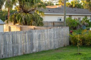
Common Problems That Can Come Up
When physical boundaries and deed descriptions do not align, it can lead to disputes between neighbors. Each party may believe they are correct based on what they see or what their paperwork says.
It can also create delays when you are trying to build or improve your property. Contractors and permitting offices rely on accurate boundary information. If there is uncertainty, plans may need to be adjusted or paused.
For those buying or selling property, these issues can raise red flags. Lenders and title companies want to be sure there are no unresolved boundary concerns before moving forward with a transaction.
How to Get Clear Answers
The best way to resolve these discrepancies is with a professional land survey. A surveyor will review the deed, examine historical records, and use modern equipment to determine the true property lines.
This process provides a clear picture of where boundaries exist today and highlights any overlaps or encroachments. It also creates documentation that can be used for legal, construction, and permitting purposes.
Starting on Solid Ground
If something about your property boundaries does not seem right, it is worth taking a closer look. Addressing the issue early can save time, money, and stress down the road.
With accurate land survey data and the support of an experienced team, you can move forward with confidence, knowing exactly where your property stands and how to plan for what comes next. Contact BLAZE Design Inc. at 802-442-2892 today or visit us online for more information!