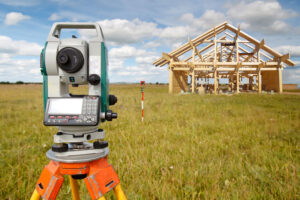
A topographic survey offers an ideal way to identify and map the surface features of the terrain in a given area. This very accurate system accounts for all of the existing objects in the area, from major features like trees, buildings and streets to every smaller item including manholes, retaining walls and utility poles.
These surveys also are best known for marking the differences in elevation of the ground surface, also known as contours. Contour lines connect different points of equal elevation and show any hills or dips in the landscape. These surveys are a great way to get a good look of the landscape, but they have several other important applications.
Construction of New Structures
One of the most common reasons to complete a topographic survey is in the case that a parcel of land is being assessed for construction or building new structures. These surveys are a great way of seeing how the land looks now and how it will look once the construction is completed. This survey also helps to identify any areas where construction may be difficult or require leveling work, not to mention the potential impact from higher slopes near the proposed construction location. Knowing the starting and end points helps the crew to understand what needs to be done to mold the land to achieve the desired results.
Three-Dimensional Planning
Architects use topographic surveys in a similar fashion, but the survey also assists them in plotting the surface in a three-dimensional way, which helps them to see how the area will look after their improvements have been implemented. The survey is also a crucial tool when presenting plans to a potential business or buyer, as they will be able to see how the property will be transformed.
Finally, a look at a completed topographic survey can help builders and architects comprehend whether or not they will be able to build in a particular area, especially if that parcel of land has particularly steep or extreme terrain. Once the lay of the land is understood, the planners can then determine whether their structures can realistically be constructed with a permanently stable foundation in that environment.
Surveying Tools for Accuracy
Topographic surveys are a tried and true surveying tool, and continue to be as useful today as they have been in centuries past. If you’re looking to get the lay of the land – literally – you need an expert. At BLAZE Design, we offer comprehensive planning and surveying services to clients in both New York and Vermont and can assess your property for you. To learn more about our services or to schedule a topographic survey of your property, call us today at 802-442-2892.